Archive - Originally posted on "The Horse's Mouth" - 2010-12-30 14:57:53 - Graham Ellis
Here's a personal list. Places I've traveled to this year - and they're all places that have not been purely for pleasure. Acton. Antrim. Avebury. Bank (London). Bath. Belfast. Birkenhead. Bradford-on-Avon. Bristol. Bristol Airport. Cambridge. Chippenham. Devizes. Dublin. Glasgow. Heathrow Airport. Henley-on-Thames. Horsham. Lacock. Lymington. Melksham. Norwich. Nurnberg. Oxford. Plymouth. Poole. Portsmouth. Radstock. Reading. Salisbury. Southampton. Southampton Airport. Stonehenge. Swanwick. Sway. Swindon. Taunton. Trowbridge. Warminster. Washington (DC). Westbury. Yeovil. The list is illustrative of the very wide range of journeys that people make - and that's where it's not just me making the journey - lots of people travel. I've welcomed people here from places as wide ranging as Llandrindod Wells to Greenwich, Chicago to Kuala Lumpur, and Chatteris to Motherwell.
Why the list? To show just how wide ranging the travel requirements can be for each of us individually. So that means there's a need for travel and transport systems to be able to provide for a disparate range of journeys - realistically with many of them involving changes of mode and connections along the way. And with good information too about the options available, how much each costs, and how to arrange it. More of my journeys that I would like have been made by car - it's the most flexible, often the fastest end to end, and there are few timing limits. BUT it burns up a lot of fuel (not green!), it can be tiring and enraging, it wastes time as I can't do things I want to (like read) as I travel, it can be expensive, and I've got to work out what to do with the car at the far end. And of course I'm fortunate enough to be fit enough to have a driving license, and well off enough to afford to run a car.
We're oft told that "Wiltshire is a rural county", and I've oft wondered what that means. The majority of the land area in Wiltshire is fields and woods - countryside - that's for starters. You'll find bats and badgers, foxes and deer, rats and other rodents ... but they don't need to travel. Staggeringly, over 70% of the population of Wiltshire live in the towns and City (and the percentage is higher if you include Swindon, which is postally still in Wiltshire). And if you look at travel-to-work, travel-to-shop, travel-to-learn, travel-to-healthcare, you'll find that the vast majority of journeys of over a mile are going to end in an urban area. Taking the under-30% of village and hamlet dwellers, you'll find a fair proportion of them in "strip development" villages that ribbon major roads - the Sells Greens, Potternes, Beanacres, Atworths and Semingtons of the county - so perhaps only 1 in 10 journey ends is where a car, taxi or other demand-responsive system is the only option. So ... "Wiltshire is a Rural County" really means "look we mustn't overlook this minority access issue that doesn't apply within cities", but it doesn't wash as a reason for NOT supporting transport within an urban area, and interurban.
Where am I headed? That for the future we need to ensure that we have a properly integrated transport system, within and without Wiltshire. The world does not stop at Salisbury in the south, nor at Swindon in the North. We need to be looking at Links - TransWilts and beyond. Look at the congestion maps, look at the time that bus services take, and the logical backbone becomes the "TransWilts" railway line ... but it's only the backbone. The backbone needs arms and legs attached to it - so we're looking not so much at "TransWilts" but at "TransWilts Link", with the majority of journeys being made not on just a train on the Swindon to Salisbury line, but beyond as well.
Here's the first of several - first draft - "TransWilts Link" maps. This one is showing rail connections that are logically useful as a part of journeys that involve the TransWilts.
On this diagram WE NEED TO ADD ... other airport connections (Bristol, Cardiff, Heathrow via Reading Railair link) ... ferry connections (Weymouth, Poole, Lymington, Southampton and Portsmouth).
Which lines and stations to include is very disputable; I've taken an educated guess at ... here are some thoughts:
My intent is to show connections / journeys / stations that would be most popular off the TransWilts trains. Tempted (but resisted) lines to Exmouth, Barnstaple, Henley, Marlow, etc ... realistically not a huge number of through journeys / potential relative to a complex map. Or could thay be added in faded grey?
For consideration on the diagram ...
1. Move Swindon towards Didcot?
2. Add Gillingham, Sherborne, Honiton, Axminster ...
3. Add Cosham?
4. Split Exeter and Portsmouth
5. Add Ashchurch, Worcester (x2), Malvern Link and Gt Malvern
6. Add Winchester
7. Extra stations on Reading - Gatwick?
8. Oldfield Park and Keynsham?
9. Stations between Pen Mill and Dorchester?
10. "To mid / North wales" from Newport?
11. More in the Thames Valley?
12. Weston and Avonmouth / Severn Beach?
Note - Solid black - core TransWilts Link
Yellow and black - some through services
Yellow - connections
I'm really not sure how vital ferries are - I was shocked as to how poor the links were and how few passengers there were at Poole, Portsmouth, Birkenhaed and Belfast in the last few months and wonder if we push those as a major selling point we're showing that we're a bit out of date. Discussion Point. To Channel Islands / Isle or Wight - different matter?
Coach Links - Cardiff, Bristol and Heathrow Airports
Bus Links - out of area ... Minehead, Stonehenge, Portland, Swanage
Click on the maps to see them larger!
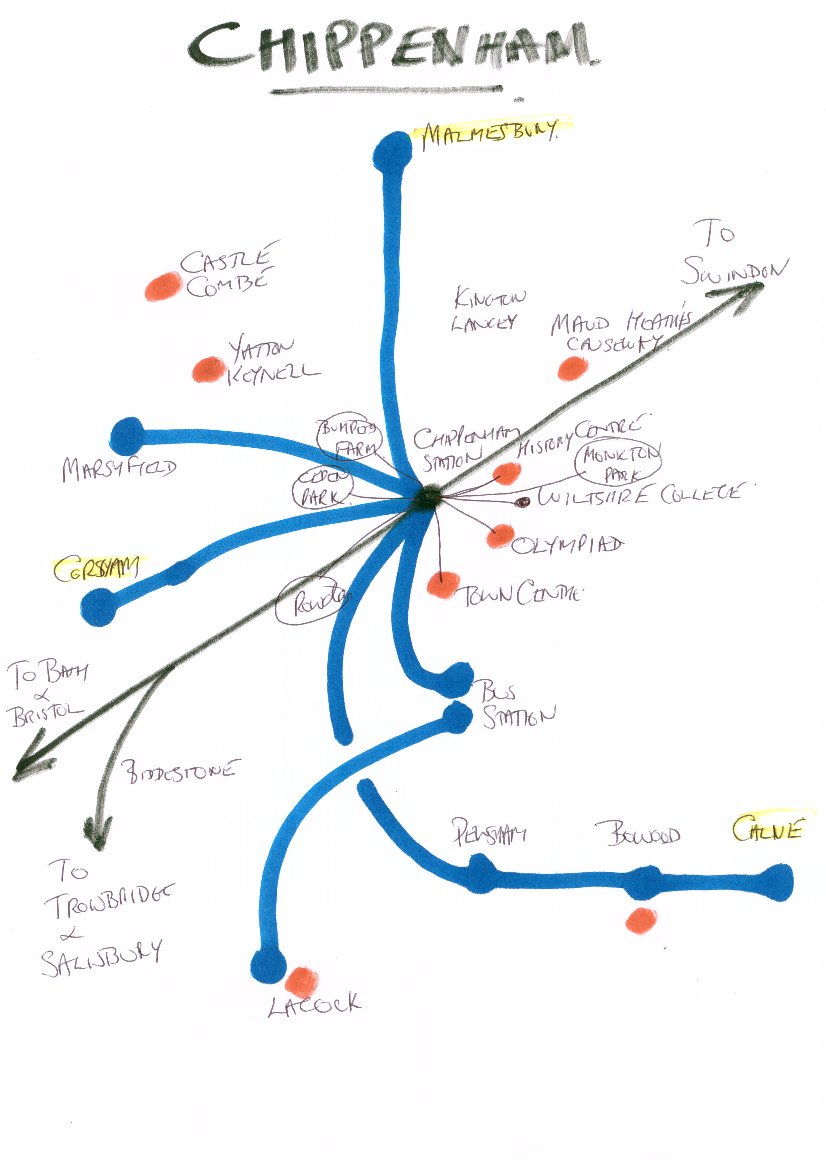
Here is a connection map - "version 0.9" if you like, as it's an early illustrative sketch - for Chippenham. The railway's shown in black, and there are think black lines from the station to places in walking distance for the typical traveler, and thicker blue lines for connecting bus services. Services shown are as at present and I've indicated those which are through the day / reasonable frequent.
Highlighted in yellow are major toens for which Chippenham is the railhead - that's Corsham, Malmesbury and Calne. It could be argued that I should have extended the Lacock line to Melksham, and branched off from Bowood to Devizes. There's also teh question as to whether the Calne line should carry on to Lyneham and Wootton Bassett.
Red markers show leisure / tourist spots. Areas of the town are also show circled - Rowden, Monkton Park, Cepen Park, Pewsham and Bumper's Farm.
Redrawn / printed with finer type as per the diagram above, further information could be added to this diagram; in the future, routes and links to information could usefully be added too
 Here is a connection map - "version 0.9" if you like, as it's an early illustrative sketch - for Chippenham. The railway's shown in black, and there are think black lines from the station to places in walking distance for the typical traveler, and thicker blue lines for connecting bus services. Services shown are as at present and I've indicated those which are through the day / reasonable frequent.